Ziro Valley is one of those places in India that people who have visited tend to describe in unusually vivid terms — a wide, flat highland bowl at nearly 1,600 metres elevation, filled with Apatani tribal villages, rice terraces, and pine forests, and flanked by the hills of Lower Subansiri district in Arunachal Pradesh. It is a UNESCO World Heritage tentative site, the venue of the famous Ziro Music Festival, and the kind of destination that would benefit enormously from easy air access. Ziro Airport exists precisely to provide that access, and while it has done so in a limited way since commercial flights resumed in October 2022, the airport’s structural constraints — a short runway, high elevation, and the boundary issues that complicate expansion — make it one of the more complex small airports in northeast India to fully understand.
Quick Overview: Ziro Airport
| Detail | Information |
| Official Airport Name | Zero Airport (AAI official name) / Ziro Airport |
| Location | Ziro, Lower Subansiri District, Arunachal Pradesh |
| Airport Type | Military/Public — Advanced Landing Ground (ALG) |
| IATA Code | ZER |
| ICAO Code | VEZO |
| Operator | Airports Authority of India (AAI) |
| Runway Designation | 18/36 |
| Runway Length | ~1,222 metres (4,010 ft) |
| Runway Width | 30 metres (100 ft) |
| Elevation | 1,590 m / 5,216 ft AMSL |
| Coordinates | 27°35′18″N, 93°49′41″E |
| Aircraft Operated | Fairchild Dornier 228 |
| Current Airline | Alliance Air |
| Active Routes | Guwahati (primary) |
| Passengers (2023–24) | 299 |
Ziro Airport Location: High-Altitude Valley in Lower Subansiri
Ziro Airport is located in Ziro town, the headquarters of Lower Subansiri district in Arunachal Pradesh. The airport address is Ziro, Lower Subansiri District, Arunachal Pradesh 791120. At an elevation of 1,590 metres (5,216 feet) above mean sea level, it is among the higher-altitude airports in India’s northeast — and one of the more unusual in that it sits within a valley bowl rather than clinging to a hillside.
Ziro Valley’s flat terrain was what made it possible to build an airstrip here at all. The Advanced Landing Ground was originally constructed in 1945–46 for military use, became operational in 1952, and has served various functions since — including air maintenance operations by the Indian Air Force and, historically, scheduled commercial service by Vayudoot and Air India. The valley’s geography is striking: the airport sits at roughly the same elevation as many small hill towns, surrounded by pine-forested ridges and the cultivated rice terraces of the Apatani people. Nearby airfields include Lilabari (North Lakhimpur) Airport approximately 42 km away, Daporijo Airport, Donyi Polo Airport (Itanagar), Jorhat Airport, and Along Airport.
Ziro Airport Code: IATA ZER and ICAO VEZO
The airport carries the IATA code ZER and the ICAO code VEZO. ZER is the booking system identifier used by airlines operating to Ziro. The ICAO code VEZO places the airport within the VE block covering eastern India and the northeast. Note that AAI’s official name for the airport is “Zero Airport” — using the older colonial-era spelling — while common contemporary usage refers to it as Ziro Airport. Both names, same facility, same codes.
Ziro Airport Terminal: Small, Functional, ALG-Standard Infrastructure
Ziro Airport operates a single passenger terminal — compact, straightforward, and sized to the airport’s current passenger volumes and aircraft types. All passenger functions occupy a single building: check-in, security screening, waiting area, baggage claim, and the exit. There are no separate domestic and international zones, no inter-terminal transfers, and no complexity in navigation. The building is a short distance from the aircraft parking area, with boarding done on foot across the apron.
The runway at 1,222 metres is the central constraint governing everything about this airport’s operations. A 2008 pre-feasibility study by the Ministry of Civil Aviation found extending the existing runway to accommodate ATR-42 class aircraft to be unfeasible — boundary encroachments had blocked the approach ends. The study instead proposed constructing a new 2,010-metre runway on adjacent land, with complete relocation of the ATC tower, fire station, and terminal building. That proposal has not been executed.
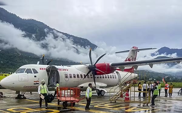
As a result, the airport can only handle Fairchild Dornier 228 aircraft — a 19-seat twin-turboprop — rather than the larger ATR-42 and ATR-72 aircraft that serve most other Arunachal Pradesh airports. The Dornier’s shorter field performance is what makes Ziro operationally possible given the current runway length and the density altitude effects of the 5,216-foot elevation.
The Arunachal Pradesh state government allocated ₹10 lakh in 2023–24 for repair and maintenance of the civil terminal building, and concrete drainage work around the airport perimeter was underway. A helipad development at Ziro under the UDAN scheme was also in progress, with an estimated cost of ₹450 lakh. These are incremental improvements rather than the structural overhaul the runway situation really requires.
Ziro Airport Connectivity: Alliance Air Routes and Access to the Valley
By Air: Alliance Air is the sole scheduled commercial carrier at Ziro Airport, operating Guwahati as the primary route using Dornier 228 aircraft. Approximately 5 flights per month have been the pattern at various points, though schedules are thin and should be verified directly before booking. The commercial flight era for Ziro resumed on 30 October 2022, when Alliance Air flagged off the route with Chief Minister Pema Khandu present — the first scheduled commercial service to Ziro in many years.
By Road: Ziro is connected to Itanagar by road, approximately 115 kilometres away with travel time of roughly 4 to 5 hours through mountain terrain. Hapoli, the main market town of Ziro Valley, is the practical hub for visitors, about 5 to 7 km from the airstrip. Local transport — taxis and shared vehicles — connects the airport to Hapoli and the rest of the valley.
Nearest Airports: Lilabari Airport (North Lakhimpur) in Assam, approximately 42 km from the valley as the crow flies but considerably further by road, is an alternative entry point for travellers reaching Ziro via Assam. Donyi Polo Airport (Itanagar/Hollongi) is the state capital airport, offering broader connectivity for those willing to combine air and road travel.
Ziro Airport Amenities: What to Expect at a High-Altitude ALG
Amenities at Ziro Airport are appropriately minimal for an Advanced Landing Ground handling under 300 passengers annually. Basic check-in counter services, security screening, and a waiting area are operational. There are no restaurants, duty-free shops, lounges, or retail facilities inside the terminal. No ATM is available at the airport.
Ground transport from the airport to Ziro town is by local taxi or private vehicle. No pre-paid taxi desk or app-based cab system operates here. Travellers arriving on the Dornier flights should arrange local transport in advance — visitor arrivals are few enough that the informal local transport ecosystem handles them without a structured system.
The airport also serves military aviation purposes as an Indian Air Force Advanced Landing Ground, which means access and operations around the airstrip are managed with the coordination protocols typical of shared civil-military facilities.
FAQs: Ziro Airport
Q: What is the IATA code for Ziro Airport?
A: The IATA code is ZER and the ICAO code is VEZO. The airport is officially named Zero Airport by AAI, though Ziro Airport is the common contemporary spelling used by travellers.
Q: Which airline flies to Ziro and how often?
A: Alliance Air operates flights to Guwahati using Dornier 228 aircraft. Frequency is thin — approximately 5 per month at various points — and should be confirmed directly with Alliance Air before booking.
Q: Why can’t larger aircraft like ATR-72 land at Ziro Airport?
A: The runway is only about 1,222 metres long. ATR-class aircraft need significantly more runway, and the 2008 feasibility study found boundary encroachments blocked straightforward extension. A new, longer runway has been proposed but not built.
Q: How do most visitors reach Ziro Valley?
A: Most travellers drive from Itanagar, a journey of approximately 115 km taking 4 to 5 hours. Those flying in use the Alliance Air Dornier service from Guwahati, with onward local transport from the airstrip to Hapoli town.
Q: Is Ziro Airport open to the public or military only?
A: It is shared — a civil enclave operated by AAI within an Indian Air Force Advanced Landing Ground. Scheduled commercial flights operate here alongside military aviation activity.