
On 28 January 2026, a Learjet 45XR operating a charter flight from Mumbai crashed on its second landing attempt at Baramati Airport in low visibility and heavy fog, killing all five on board including Maharashtra’s Deputy Chief Minister Ajit Pawar. The crash — one of the most politically consequential aviation accidents in Maharashtra’s history — brought national attention to a small MIDC-built airstrip in Pune district that had quietly served general aviation, charter flights, and VIP movements since 1996 without ever hosting scheduled commercial passenger flights. Baramati Airport carries no IATA code and no standard ICAO code. It is listed under UDAN 5.2 for bidding, pending Maharashtra government consent and land availability confirmation. Following the crash, Chief Minister Devendra Fadnavis committed to comprehensive development of the Baramati facility under MADC, and the airport was named Dadasaheb Ajit Anantrao Pawar Airport in Ajit Pawar’s memory. Both the commercial development plans and the post-crash safety upgrade process were ongoing as of mid-2026.
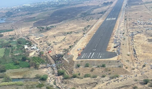
Quick Overview: Baramati Airport
| Detail | Information |
| Official Name | Dadasaheb Ajit Anantrao Pawar Airport (renamed post-January 2026 crash) |
| Also Known As | Baramati Airport; Baramati Airstrip |
| Location | Gojubavi, Baramati, Pune district, Maharashtra, India |
| Airport Type | Public — General aviation / Charter (no scheduled commercial service) |
| IATA Code | Not Assigned |
| ICAO Code | Not Assigned (IN-0024 used as informal reference in pilot databases) |
| Owner | Maharashtra Industrial Development Corporation (MIDC) |
| Operator | MIDC |
| Constructed | 1996 |
| Runway Designation | 11/29 |
| Coordinates | 18°13′43″N, 74°35′04″E |
| Elevation | 604 m / 1,982 ft AMSL |
| Distance from Baramati City | ~12 km |
| Nearest Weather Station | Navi Mumbai International Airport (~181 km) |
| Flight Information Region | Mumbai FIR |
| Scheduled Commercial Flights | None |
| UDAN Status | Listed under UDAN 5.2 for bidding; awaiting state consent and land availability |
| January 2026 Crash | Learjet 45XR VT-SSK; 5 fatalities including Dy CM Ajit Pawar |
| Post-Crash Development Commitment | MADC to develop runway, navigation systems, ATC upgrade |
| Flying Training Organisation | One FTO present at the airstrip |
Baramati Airport Location: Gojubavi in Pune District’s Sugar Belt
Baramati Airport is located at Gojubavi village, approximately 12 kilometres from Baramati city and Baramati Railway Station. Coordinates are 18°13′43″N, 74°35′04″E, at an elevation of 604 metres above mean sea level. The airport is in Pune district’s eastern Baramati taluka — a zone famous for sugar cooperatives, wine production (the Sahyadri wines from nearby Nashik-Baramati region), cooperative banking, and as the political constituency of the Pawar family dynasty that has dominated Maharashtra politics for four decades.
Baramati’s identity is inseparable from the Pawar family. The late Sharad Pawar established MIDC and other cooperative institutions here, building Baramati into a model cooperative economy with industrial estates, a sugar mill, an engineering college, and the airport. The MIDC constructed Baramati Airport in 1996 specifically as part of this industrial township development vision — intended to attract investors, facilitate executive transport, and serve as a base for general aviation activities supporting the cooperative industrial ecosystem.
The Baramati Agro Limited — one of India’s leading agri-business cooperatives — and the D.Y. Patil International School and Engineering College are among the prominent institutions in the area. The airport’s general aviation and charter role served executives visiting these facilities.
Nearby airfields in pilot navigation databases include Pune International Airport (approximately 80 km northwest), Karad Airport, Aamby Valley Airport, and Solapur Airport. The nearest weather station is Navi Mumbai International Airport at approximately 181 km — an extreme distance that reflects the absence of aviation weather monitoring infrastructure in Baramati’s zone, and which was directly relevant to the January 2026 accident that occurred in foggy conditions without instrument approach facilities.
Baramati Airport Code: No IATA, No Standard ICAO
Baramati Airport has no assigned IATA code and no standard ICAO code. The informal reference IN-0024 is used in pilot navigation databases (metar-taf.com, OurAirports) as a positional identifier. The local FAA LID is BMT. No METAR data is published — the absence of weather reporting at the airport, combined with the lack of instrument landing systems, was a safety gap highlighted in post-crash investigations following the January 2026 accident. The Flight Information Region is Mumbai FIR.
Baramati Airport Terminal: An MIDC Airstrip Reshaped by Tragedy
Baramati Airport was constructed by the Maharashtra Industrial Development Corporation in 1996 as a single-runway general aviation airstrip. The runway is oriented 11/29 (headings of approximately 110 and 290 degrees). The airstrip has basic general aviation infrastructure — ground operations, fuel, and a small flying training organisation (FTO) that uses the airfield for pilot training activities. No passenger terminal for commercial use exists. No check-in counters, departure lounge, or commercial baggage handling have been built.
The airport’s character was general aviation and VIP charter. Politicians, industrialists, and cooperative leaders associated with the Baramati economy used charter flights into the airstrip regularly. The largest political family in Baramati — the Pawars — were among the most frequent users.
The January 2026 Crash: On 28 January 2026, at approximately 9:12 AM, a Learjet 45XR (VT-SSK) operated by VSR Ventures Aviation was on a charter flight from Chhatrapati Shivaji Maharaj International Airport, Mumbai to Baramati. During the second landing attempt in low visibility and heavy fog — conditions the airstrip had no instrument approach procedure to handle — the aircraft lost control and crashed, exploding on impact. All five on board were killed: Deputy Chief Minister Ajit Pawar (who had served Maharashtra as both Deputy Chief Minister and Minister of Finance across multiple tenures and was Baramati’s most prominent political figure), along with pilot Sumit Kapur (16,500 flight hours), co-pilot, and two passengers.
Post-Crash Development Commitment: Chief Minister Devendra Fadnavis committed within days of the crash that the Maharashtra state government would undertake comprehensive development of Baramati Airport under MADC. Specific commitments included: runway strengthening, installation of modern navigation systems, and upgrade of air traffic monitoring. The airport was renamed Dadasaheb Ajit Anantrao Pawar Airport in Ajit Pawar’s memory. Implementation of the development plan was ongoing as of mid-2026.
UDAN 5.2 Status: The Civil Aviation Ministry informed Parliament in response to a question submitted by Sunetra Pawar (Ajit Pawar’s wife) — before the crash occurred, indicating her longstanding interest in the airport’s development — that Baramati airstrip is listed under UDAN 5.2 for bidding but awaits Maharashtra government consent and land availability confirmation. The same parliamentary response addressed plans for night landing facilities and FTO modernisation, all of which became more urgent in the post-crash context.
Baramati Airport Connectivity: Charter and Training; No Commercial Flights
By Air: No scheduled commercial passenger flights operate from Baramati Airport. The airfield has served VIP charters, private jets, and charter aircraft for the Baramati industrial and political community. The FTO on site provides pilot training flights. Following the January 2026 crash and the subsequent safety review, charter operations may also be temporarily restricted pending safety infrastructure improvements. Confirm current operational status before any charter flight planning.
By Road: Baramati city is approximately 12 km from the airport. Pune is approximately 80 km northwest via State Highway 27 — about 1.5 to 2 hours. Solapur is approximately 150 km southeast. MSRTC buses connect Baramati to Pune, Solapur, and other Maharashtra cities. Local taxis provide airport-to-city connectivity.
By Rail: Baramati Railway Station — approximately 12 km from the airport — is on the Daund-Baramati branch line of the Central Railway, connected to Daund Junction (approximately 42 km north) where mainline trains to Pune, Mumbai, and Solapur can be boarded. Rail connectivity to Pune from Daund is approximately 2 to 2.5 hours.
Nearest Commercial Airport: Pune Airport (PNQ, Lohegaon) at approximately 80 km northwest is the nearest major commercial airport — one of India’s busiest, with extensive domestic and some international connectivity.
Baramati Airport Amenities: General Aviation Facilities; No Public Passenger Services
There are no public passenger amenities at Baramati Airport. The MIDC-owned airstrip provides basic general aviation infrastructure — ground operations, fuel, and FTO training facilities. No passenger terminal, check-in counters, departure lounge, commercial food services, or commercial baggage handling exist for public use.
Post-crash, the development plan announced by CM Fadnavis will add navigation systems and runway strengthening. If UDAN 5.2 bidding proceeds successfully and state consent and land availability are confirmed, a small commercial terminal building would be constructed as part of the UDAN-standard development package. Until then, Baramati Airport serves private aviation only.
FAQs: Baramati Airport
Q1. Does Baramati Airport have an IATA or ICAO code?
No. Baramati Airport has no assigned IATA code and no standard ICAO code. The informal pilot reference IN-0024 appears in navigation databases. The airport is not in any airline booking system. Its post-crash official name is Dadasaheb Ajit Anantrao Pawar Airport.
Q2. What happened at Baramati Airport on 28 January 2026?
A Learjet 45XR (VT-SSK) operating a charter flight from Mumbai crashed during its second landing attempt at Baramati Airport in heavy fog and low visibility. All five on board were killed, including Maharashtra Deputy Chief Minister Ajit Pawar, pilot Sumit Kapur, and three others. The crash highlighted safety gaps at smaller uncontrolled airstrips including the absence of instrument approach procedures.
Q3. Who was Ajit Pawar?
Ajit Pawar was a veteran Maharashtra politician, Deputy Chief Minister, and Finance Minister across multiple tenures — the nephew of Sharad Pawar and a dominant figure in the NCP and Maharashtra politics for over three decades. Baramati was his home constituency. The airport was renamed Dadasaheb Ajit Anantrao Pawar Airport in his memory.
Q4. What development is planned for Baramati Airport post-crash?
CM Devendra Fadnavis announced MADC will implement runway strengthening, modern navigation systems, and ATC upgrade. The airport is listed under UDAN 5.2 for commercial service bidding, pending Maharashtra government consent and land availability. The Civil Aviation Ministry had also addressed FTO modernisation at the site.
Q5. Can passengers fly commercially from Baramati Airport?
No. Baramati Airport has no scheduled commercial passenger service. It handles private charters, VIP flights, and pilot training. The nearest commercial airport is Pune Airport (PNQ) at approximately 80 km.


