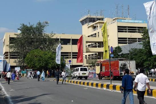
Begumpet Airport served as Hyderabad’s sole commercial aviation gateway for over seven decades — from the founding of the Hyderabad State Aero Club there in June 1936, through the Nizam’s era, through independence, through the IT boom that transformed Hyderabad into Cyberabad, until 23 March 2008 when Rajiv Gandhi International Airport opened at Shamshabad and every scheduled commercial passenger flight moved south. Since that date, Begumpet has operated as a military and general aviation facility — home to the Begumpet Air Force Station, the Andhra Pradesh Aviation Academy, the Rajiv Gandhi Aviation Academy, and the Navigation Training School of the IAF’s Training Command. It carries IATA code BPM and ICAO code VOHY, publishes METAR weather data (confirming active aviation operations), and hosts the biennial Wings India civil aviation air show. No scheduled commercial passenger flights operate here.
Quick Overview: Begumpet Airport
| Detail | Information |
| Official Name | Begumpet Airport (also: Hyderabad Old Airport) |
| Location | Begumpet, Hyderabad, Telangana, India |
| Airport Type | Military/Public — General aviation (no scheduled commercial service) |
| IATA Code | BPM |
| ICAO Code | VOHY |
| Owner/Operator | Airports Authority of India (AAI) |
| Opened | June 1936 (Hyderabad State Aero Club inauguration) |
| Commercial Passenger Services Ceased | 23 March 2008 |
| Elevation | 532 m / 1,744 ft AMSL |
| Coordinates | 17°27′11″N, 78°28′03″E |
| Distance from City Centre | ~5 km from Secunderabad |
| Distance from RGIA (HYD) | ~24 km south |
| Institutions | AP Aviation Academy; Rajiv Gandhi Aviation Academy; IAF Navigation Training School |
| Wings India Airshow | Biennial (even years); held at Begumpet |
| Scheduled Commercial Flights | None |
Begumpet Airport Location: The Heart of Hyderabad
Begumpet Airport is located in the Begumpet neighbourhood of Hyderabad, approximately 5 km from Secunderabad and approximately 8 km from the Charminar. The coordinates are 17°27′11″N, 78°28′03″E, at an elevation of 532 metres. This central urban position — within Hyderabad’s established residential and commercial zones — is precisely the advantage that has made its commercial revival a persistent political demand. For the city’s IT community in Madhapur and Hitec City, Begumpet is dramatically closer than RGIA’s 24 km distance from the same neighbourhoods.
Princess Dürrüşehvar of the Nizam’s family laid the foundation stone for the terminal building in November 1936, five months after the aero club’s inauguration. Tata Airlines’ Karachi-Madras route was rerouted through Begumpet in 1937 (replacing Hakimpet airfield). The Nizam’s own airline, Deccan Airways, began India’s first private airline service from here in 1945. The airport was the sole civilian gateway to Hyderabad for 71 years.
Code, Terminal, and Current Use
IATA BPM and ICAO VOHY are the formal codes. VOHY publishes METAR data confirming active general aviation and IAF operations. The existing terminal buildings house the aviation academies. Wings India — the civil aviation air show organised by the Ministry of Civil Aviation — is held biennially at Begumpet in even years (2026 edition was scheduled).
HAL’s MiG-21 repair facility and the IAF Navigation Training School (formerly Navigation and Signals School) are based here. Proposals for commercial revival — similar to HAL Bengaluru — have been discussed but face the RGIA concession agreement which has a 150-km exclusivity clause through certain years. As of mid-2026, no commercial passenger airline operated from BPM.
Connectivity and Amenities
By Air: No scheduled commercial flights. The nearest commercial airport is Rajiv Gandhi International Airport (HYD), 24 km south.
By Road: Begumpet is central Hyderabad — 5 km from Secunderabad. Taxis, Ola, Uber, and TSRTC buses serve the area extensively.
By Metro: Hyderabad Metro’s Red Line passes through Begumpet — Begumpet Metro Station is adjacent to the airport campus.
No public commercial passenger amenities. The Wings India air show brings temporary public-facing infrastructure during the biennial event.
FAQs: Begumpet Airport
Q1. What is the IATA code for Begumpet Airport?
BPM is the IATA code and VOHY is the ICAO code. The airport is in Begumpet, Hyderabad, approximately 5 km from Secunderabad.
Q2. When did Begumpet stop commercial flights?
23 March 2008, the day Rajiv Gandhi International Airport at Shamshabad opened. All scheduled commercial passenger operations moved to RGIA on that day.
Q3. What happens at Begumpet Airport today?
The IAF operates Begumpet Air Force Station and Navigation Training School. The Andhra Pradesh Aviation Academy and Rajiv Gandhi Aviation Academy provide pilot training. The biennial Wings India civil aviation air show is held here in even years.
Q4. Is there Metro access to Begumpet Airport?
Yes — Begumpet Metro Station on Hyderabad Metro’s Red Line is adjacent to the airport campus, making it one of the few Indian airports (even non-commercial ones) with direct Metro connectivity.
Q5. Could Begumpet Airport be revived for commercial flights?
Proposals have been raised but face the RGIA concession’s exclusivity clause. As of mid-2026, no commercial revival plan had been formally approved.