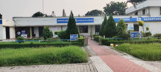
Pantnagar is a planned city in Uttarakhand’s Tarai belt — established in the 1950s around Govind Ballabh Pant University of Agriculture and Technology (G.B. Pant University), which was India’s first agricultural university. The Tarai zone here is flat, fertile, and contrasts sharply with Uttarakhand’s predominantly hilly identity — this is the state’s agricultural and industrial flat-land corridor. SIDCUL’s Integrated Industrial Estate at Pantnagar has attracted major manufacturers including Tata Motors, Hero MotoCorp, Bajaj Finance, and other Tier-1 industrial firms. Pantnagar Airport, the nearest commercial airport to Kumaon’s famous hill stations (Nainital 65 km, Jim Corbett National Park 120 km), carries IATA code PGH and ICAO code VIPT. It handled 1,01,013 passengers in 2024–25 (+8.9%), connects to Delhi through IndiGo, and is in the midst of an ambitious expansion targeting international status with 804 acres acquired including from G.B. Pant University.
Quick Overview: Pantnagar Airport
| Detail | Information |
| Official Name | Pantnagar Airport |
| Location | Pantnagar, Udham Singh Nagar district, Uttarakhand – 263145 |
| Serves | Pantnagar, Rudrapur, Haldwani, Kichha, Nainital (~65 km) |
| Airport Type | Public — Domestic |
| IATA Code | PGH |
| ICAO Code | VIPT |
| Owner | Government of Uttarakhand |
| Operator | Airports Authority of India (AAI) |
| Runway Designation | 10/28 |
| Runway Length | 1,372 m (4,500 ft) × 30 m (100 ft) — asphalt |
| Expansion Plan | 7,000 ft (2,134 m) × 45 m; international status targeted |
| Land Acquired | 804 acres (from G.B. Pant University and others); 524.7 acres registered |
| Navigational Aid | NDB (Non-Directional Beacon) at 400 kHz |
| Terminal | Arrival: 180 sq. m; Departure: 75 sq. m; Security Hold: 90 sq. m |
| Capacity | 50 arrivals + 20 departures at a time |
| Elevation | 233 m / 764 ft AMSL |
| Coordinates | 29°01′56″N, 79°28′27″E |
| Distance from Nainital | ~65 km (~1.5 hours) |
| Distance from Jim Corbett | ~120 km (~2.5 hours) |
| Passengers (2024–25) | 1,01,013 (+8.9% YoY) |
| Aircraft Movements (2024–25) | 2,160 (+2.7% YoY) |
| Current Airline | IndiGo |
| Active Route | Delhi (twice daily) |
| Aero City Plan | Planned outside airport for passengers, entrepreneurs, tourists |
Pantnagar Airport Location: Kumaon’s Aviation Gateway on the Tarai Flatlands
Pantnagar Airport is located in Pantnagar town, Udham Singh Nagar district, at coordinates 29°01′56″N, 79°28′27″E, at an elevation of 233 metres above sea level. The flat Tarai plains of southern Uttarakhand — significantly lower than Kumaon’s famous hill stations — provide the level terrain needed for a runway where the surrounding hills do not.
The airport’s tourism catchment is among the most scenically rich in India. Nainital — the City of Lakes with its famous Naini Lake, Naina Devi Temple, and Tiffin Top viewpoint — is 65 km north (approximately 1.5 hours by road). Bhimtal is 50 km. Ranikhet is 110 km. Jim Corbett National Park — India’s oldest tiger reserve and one of the world’s most famous wildlife destinations — is 120 km east. Almora’s hilltop setting with its medieval temples is 120 km. The Ananda in the Himalayas resort at Narendra Nagar (near Rishikesh) is approximately 150 km west.
SIDCUL Pantnagar’s industrial estate — with Tata Motors, Hero MotoCorp, and dozens of automotive and manufacturing companies — generates business aviation demand that sustains the airport’s thin but consistent commercial viability.
Code, Terminal and Expansion Plans
IATA PGH and ICAO VIPT are the formal codes. The current terminal is the most compact among commercially operational airports in India — an arrival hall of just 180 square metres, a departure hall of 75 square metres, and a security hold area of 90 square metres. Total simultaneous capacity: 50 arriving and 20 departing passengers. Two check-in counters, one entry gate, and two X-ray baggage scanners constitute the full processing infrastructure.
This compact terminal reflects the airport’s 1,372-metre runway limitation — only ATR-72 class turboprops can operate here, limiting passenger volume to levels the modest terminal can handle. IndiGo’s twice-daily Delhi service using ATR-72 aircraft makes Nainital and Kumaon accessible by air from the capital in approximately 1 hour.
The expansion is transformational in ambition. A total of 804 acres have been acquired from various departments including G.B. Pant Agricultural University, with 524.7 acres registered with the civil aviation department. The planned runway extension to 7,000 feet (2,134 metres) × 45 metres will enable Airbus A320 class jet operations. Uttarakhand CM Dhami announced progress toward international airport status in August 2025. An aero city outside the airport perimeter is also being planned, with a high-level state government meeting directing the aviation department secretary to coordinate its development. Once international and jet-capable, Pantnagar could become a genuine competing gateway to Kumaon for tourists flying from outside UP.
Connectivity and Amenities
By Air: IndiGo operates twice-daily Delhi flights using ATR-72 aircraft. No other airlines or routes as of mid-2026. Confirm current schedule before booking.
By Road: Nainital is 65 km (1.5 hours). Jim Corbett National Park is 120 km (2.5 hours). Haldwani — Kumaon’s commercial capital — is approximately 25 km (30 minutes). Rudrapur is approximately 20 km (25 minutes). Dehradun’s Jolly Grant Airport is approximately 200 km west (3.5 hours).
By Rail: Kathgodam Railway Station — terminus of the Shatabdi Express from Delhi, serving the Kumaon hill station corridor — is approximately 45 km from the airport (1 hour by road). The Delhi-Kathgodam Shatabdi takes approximately 6 hours from Delhi.
Amenities: Two check-in counters, security screening, a compact departure lounge, 18 car parking lots (chargeable), basic food and beverage, and restrooms. No premium lounge. The airport’s compact size means the check-in to aircraft experience is exceptionally fast — typically under 20 minutes.
FAQs: Pantnagar Airport
Q1. What is the IATA code for Pantnagar Airport?
PGH is the IATA code and VIPT is the ICAO code. The airport is in Pantnagar, Udham Singh Nagar district, Uttarakhand, operated by AAI.
Q2. What airlines and routes serve Pantnagar Airport?
IndiGo operates twice-daily Delhi flights using ATR-72 aircraft. Confirm current schedule before booking as regional timetables adjust seasonally.
Q3. How far is Pantnagar Airport from Nainital and Jim Corbett?
Nainital is approximately 65 km north (1.5 hours by road). Jim Corbett National Park is approximately 120 km east (2.5 hours). Pantnagar is the nearest commercial airport for Kumaon’s hill station and wildlife tourism circuit.
Q4. What expansion is planned for Pantnagar Airport?
804 acres acquired (including from G.B. Pant University) for a runway extension from 1,372 m to 2,134 m (7,000 ft) — enabling A320 jet operations. International airport status is targeted. An aero city adjacent to the airport is also planned. CM Dhami announced progress in August 2025.
Q5. How compact is Pantnagar Airport’s terminal?
Extremely — just 180 sq. m arrivals, 75 sq. m departures, and 90 sq. m security hold, with 50 arrival and 20 departure simultaneous capacity. Its small size means check-in to boarding takes under 20 minutes — one of the fastest airport experiences in India.