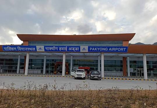
India’s 100th operational airport opened on 24 September 2018 — and it opened with a view that no other airport in the country can match. Pakyong Airport sits on a ridge at 1,416 metres above sea level in Sikkim’s East district, 30 to 35 kilometres southeast of Gangtok, with Kanchenjunga — the world’s third-highest mountain — visible on clear days from the runway. Getting there required cutting away part of a Himalayan hillside and building a tabletop platform in terrain so steep that the approach paths take pilots into valleys before climbing to the ridge. The result is one of India’s most extraordinary engineering achievements and one of its most weather-vulnerable airports. Carrying IATA code PYG and ICAO code VEPY, Pakyong Airport has struggled since inauguration with visibility disruptions, airline exits, and persistent operational volatility — and as of 2025–26, recorded zero scheduled commercial passengers for the full year, with flights suspended since June 2024.
Quick Overview: Pakyong Airport
| Detail | Information |
| Official Name | Pakyong Airport |
| Location | Pakyong, Pakyong district, Sikkim, India |
| Serves | Gangtok (~30–35 km northwest) |
| Airport Type | Public — Domestic |
| IATA Code | PYG |
| ICAO Code | VEPY |
| Owner | Government of India |
| Operator | Airports Authority of India (AAI) |
| Inaugurated | 24 September 2018 (India’s 100th operational airport) |
| First Commercial Flights | October 2018 (SpiceJet, Druk Air) |
| Terminal Area | ~2,380 sq. metres |
| Terminal Capacity | 100 passengers |
| Area | 200+ acres |
| Car Parking | ~100 vehicles |
| Runway Designation | Tabletop |
| Runway Length | 1,700 m × 30 m |
| Elevation | 1,416 m / 4,646 ft AMSL |
| Coordinates | 27°13′57″N, 88°35′18″E |
| Distance from Gangtok | ~30–35 km southeast |
| Passengers (2025–26) | 0 (−100% YoY; flights suspended since June 2024) |
| Passengers (2024–25) | Data confirmed minimal to nil |
| Scheduled Commercial Flights | Suspended as of mid-2026 |
| Nearest Alternative Airport | Bagdogra Airport (IXB), West Bengal — ~124 km from Gangtok |
Pakyong Airport Location: A Ridge in the Himalayan Foothills
Pakyong Airport is located in Pakyong village, Pakyong district, Sikkim, approximately 30 to 35 kilometres southeast of Gangtok. The coordinates are 27°13′57″N, 88°35′18″E, at an elevation of 1,416 metres above sea level — placing it among the five highest airports in India. The ridge-top location overlooks deep Himalayan valleys in all directions, with the Teesta River visible in the gorge below and the Kanchenjunga massif (8,586 metres) dominating the northern horizon on clear days.
The terrain around Pakyong Airport explains both why it is where it is and why it is so operationally challenging. Sikkim is entirely mountainous — there is no flat ground anywhere in the state for a conventional airport. The Pakyong ridge was identified as the only feasible location within reach of Gangtok where a plateau could be artificially created. AAI cut away portions of the hillside, reinforced the embankments with massive retaining walls, and built the tabletop runway that drops away sharply at both ends — a design similar to Kozhikode and Mangaluru but at far greater altitude and in far more complex terrain.
The drive from the airport to Gangtok takes approximately 60 to 75 minutes along winding Himalayan roads — offering views of terraced cardamom and tea gardens, forested ridges, and the Teesta valley.
Pakyong Airport Code: IATA PYG and ICAO VEPY
The IATA code is PYG and the ICAO code is VEPY. PYG appears in airline systems when searching for Gangtok or Sikkim. VEPY places it in the VE eastern India block. The airport holds formal AAI operational status and publishes aviation data — though the 2025–26 data showing zero passengers and zero aircraft movements reflects the commercial suspension rather than any change in infrastructure status.
Pakyong Airport Terminal: Engineering Marvel, Operational Fragility
The terminal at Pakyong Airport covers 2,380 square metres and handles 100 passengers simultaneously. It has check-in counters, security screening, a departure lounge, an ATC tower, and a fire station — all within a single building on the hilltop platform. Car parking for approximately 100 vehicles serves private transfers. The surrounding view from the terminal apron — valleys falling away hundreds of metres in multiple directions — makes Pakyong one of the most visually dramatic airport settings in Asia.
The operational history since the 2018 inauguration has been extremely difficult:
2018–2020: SpiceJet and Druk Air launched initial services. SpiceJet’s Kolkata route operated intermittently. Druk Air ran Thimphu-Pakyong-Kolkata services for a period. Weather disruptions — low cloud, fog, and the valley terrain creating dangerous wind shear on approach — caused high flight cancellation rates from the start.
COVID-19 (2020–2022): All services suspended.
Post-COVID revival attempts: IndiGo, SpiceJet, and Alliance Air all attempted revived routes at various points. Services would operate briefly, face heavy cancellation rates due to weather, and then suspend again. The airport’s monsoon period (June-September) is particularly treacherous — cloud fills the valleys and approaches become VFR-only with minimal operating windows.
June 2024 suspension: Commercial flights at Pakyong were suspended from June 2024. The 2025 winter schedule (October 2025–March 2026) did not include any Pakyong services. The full 2025–26 AAI statistical year records zero passengers and zero aircraft movements — the first time since inauguration that the airport recorded no commercial activity at all.
The combination of high altitude (engine and wing performance reduction), tabletop terrain, frequent low cloud, and approaches through deep valleys makes Pakyong operationally among the most challenging airports in India. The commercial demand from Sikkim’s growing tourism sector exists — approximately 15 lakh visitors in 2023 — but airlines find the cancellation rates commercially and operationally unacceptable without significant improvement in navigation infrastructure.
Pakyong Airport Connectivity: No Current Scheduled Flights; Bagdogra is the Practical Alternative
By Air: No scheduled commercial passenger flights operate from Pakyong Airport as of mid-2026. The airport has been commercially suspended since June 2024. Confirm any resumption of services before any travel planning involving PYG — do not book travel to Sikkim assuming air connectivity at Pakyong.
Practical Alternative — Bagdogra Airport (IXB): Bagdogra Airport in West Bengal, approximately 124 km from Gangtok, is the practical aviation gateway for Sikkim. IndiGo, Air India, SpiceJet, and Akasa Air connect Bagdogra to Delhi, Mumbai, Kolkata, Bengaluru, and other cities. The road journey from Bagdogra to Gangtok — through the Teesta valley, climbing through the Sikkim border at Rangpo — takes approximately 4 to 5 hours by shared taxi or private vehicle and costs ₹200 to ₹500 per person in shared vehicles.
By Road: The airport is 30 to 35 km from Gangtok — approximately 60 to 75 minutes on mountain roads. The approach from Siliguri (West Bengal) via Rangpo is approximately 3 to 4 hours from Bagdogra Airport.
Pakyong Airport Amenities: Built But Inactive
The terminal at Pakyong Airport is physically intact — the building, ATC tower, fire station, and car park exist and are maintained. However, with no commercial flights operating, the passenger-facing amenities are not in active public use. There are no check-in counters processing passengers, no departure lounge serving travellers, and no commercial ground transport desks for airline passengers.
The airport’s infrastructure — if and when commercial services resume — includes the full domestic airport service package: check-in, security screening, departure lounge, and basic food and beverage. The tabletop setting and Himalayan views will remain its defining passenger experience.
FAQs: Pakyong Airport
Q1. What is the IATA code for Pakyong Airport?
The IATA code is PYG and the ICAO code is VEPY. The airport is in Pakyong, approximately 30 to 35 km southeast of Gangtok, Sikkim. It is Sikkim’s only airport.
Q2. Are there currently scheduled flights from Pakyong Airport?
No. Commercial flights have been suspended since June 2024. The full 2025–26 AAI statistical year recorded zero passengers and zero aircraft movements. As of mid-2026, no airline operated scheduled services from PYG. Always confirm current status before travel planning.
Q3. Why does Pakyong Airport have such poor operational reliability?
The airport’s tabletop runway at 1,416 metres elevation sits on a Himalayan ridge with deep valleys on all approaches. High altitude reduces aircraft performance. Frequent low cloud, fog, and wind shear from valley terrain cause high cancellation rates. The monsoon season (June-September) is particularly challenging — cloud fills the valleys and VFR-only approaches become impractical for days at a stretch.
Q4. What is the practical way to reach Gangtok by air?
Fly to Bagdogra Airport (IXB) in West Bengal — approximately 124 km from Gangtok — served by IndiGo, Air India, SpiceJet, and other carriers. From Bagdogra, the road journey to Gangtok via Rangpo takes 4 to 5 hours by shared taxi or private vehicle.
Q5. What is historically notable about Pakyong Airport?
Pakyong was inaugurated on 24 September 2018 as India’s 100th operational airport. It is one of India’s highest airports at 1,416 metres. Its construction required cutting a tabletop platform into a steep Himalayan ridge — one of the most challenging airport engineering projects AAI has undertaken.