
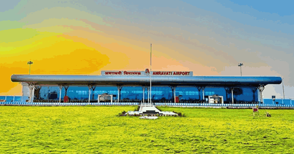
Amravati is a city in eastern Maharashtra’s Vidarbha region — the capital of Amravati district and the headquarters of the Amravati Division, a zone of cotton fields, orange orchards, wildlife sanctuary, and one of India’s most visited hill stations for Maharashtra’s residents: Chikhaldara. The city has an aviation history of announcements and delays that stretched across thirteen years before the airport finally opened for commercial operations on 16 April 2025, when Chief Minister Devendra Fadnavis inaugurated the facility at Belora village. IATA code AVR, ICAO code VAAM — Amravati Airport at Belora is the third commercial airport under the Maharashtra Airport Development Company (MADC), covering 389 hectares, with a 1,850-metre runway, a 2,600-square-metre terminal, and Alliance Air’s Mumbai service as the inaugural and primary scheduled route.
Quick Overview: Amravati Airport
| Detail | Information |
| Official Name | Amravati Airport (also: Belora Airport) |
| Location | Belora, Amravati district, Maharashtra, India |
| Serves | Amravati city (~15 km north) |
| Airport Type | Public — Domestic (Greenfield) |
| IATA Code | AVR |
| ICAO Code | VAAM |
| Owner | Government of Maharashtra |
| Operator | Maharashtra Airport Development Company (MADC) |
| Inaugurated | 16 April 2025 (CM Devendra Fadnavis) |
| First Flight | Alliance Air |
| Land Area | 389 hectares (~961 acres) |
| Runway Designation | 08/26 |
| Runway Length | 1,850 m × 45 m |
| Taxiway | 163 m × 18 m |
| Apron | 100 m × 110 m |
| Terminal Area | 2,600 sq. metres |
| ATC Tower Height | 26 metres |
| Night Landing Facility | Under installation as of inauguration |
| Elevation | 347 m / 1,137 ft AMSL |
| Coordinates | 20°48′48″N, 77°43′04″E |
| Distance from Amravati City | ~15 km south |
| Distance from Nagpur | ~150 km |
| Distance from Akola | ~65 km west |
| Current Airline | Alliance Air |
| Active Route | Mumbai (direct morning service) |
| Winter Schedule | Included in October 2025–March 2026 national schedule |
| Future Plan | Runway extension for A320/B737; Air India FTO integration |
Amravati Airport Location: Belora in Eastern Vidarbha
Amravati Airport is located in Belora village, approximately 15 kilometres south of Amravati city centre. Coordinates are 20°48′48″N, 77°43′04″E, at an elevation of 347 metres above mean sea level. The airport is accessible via Belora Airport Road, connecting to National Highway 53 (NH-53 — the Bharat Mala Expressway corridor connecting Mumbai to Nagpur and eastern India).
Amravati’s geographic position in eastern Vidarbha gives the airport a catchment covering the cotton and orange-producing agricultural zones of Amravati, Yavatmal, Washim, and Wardha districts. The city is approximately 150 km from Nagpur — a distance that makes air connectivity to Mumbai and other cities practically valuable for Amravati’s residents, who would otherwise face a 10 to 12-hour road journey or a circuitous rail route.
Chikhaldara — Maharashtra’s only hill station in Vidarbha, situated in the Satpura range at approximately 1,100 metres elevation — is approximately 100 km from the airport and is a significant tourism draw for Amravati and the broader Vidarbha region. Melghat Tiger Reserve, which adjoins the Chikhaldara forest area, adds wildlife tourism demand to the aviation catchment.
The thirteen-year delay from project announcement to inauguration is a widely documented aspect of Amravati Airport’s history. Land acquisition challenges, environmental clearances, shifting state government priorities, and the COVID-19 pandemic all contributed to a timeline that frustrated Amravati’s residents and politicians across multiple government terms.
Amravati Airport Code: IATA AVR and ICAO VAAM
The airport’s IATA code is AVR and its ICAO code is VAAM. The IATA code AVR was formally assigned to Amravati Airport following its operational licensing. VAAM places it in the VA western India block. The airport entered the national aviation schedule when it was included in the October 2025 to March 2026 winter schedule as part of 26,495 weekly domestic flights across 126 airports nationwide.
Amravati Airport Terminal: New Greenfield Building With Night Landing Pending
The terminal building at Amravati Airport covers 2,600 square metres — a modest but appropriately sized structure for a newly opened regional airport targeting initial UDAN-scheme traffic volumes. The runway at 1,850 metres × 45 metres (designated 08/26) is capable of handling ATR-72 class turboprops and smaller regional jet aircraft at reduced loads. Plans exist for runway extension to accommodate Airbus A320 and Boeing 737 class narrow-body jets — which would dramatically expand the commercial airline interest in Amravati routes.
The ATC tower stands at 26 metres. The apron (100 × 110 metres) and taxiway (163 × 18 metres) provide the airside infrastructure for initial operations. Night landing facilities were under installation at the time of inauguration in April 2025 — not yet available at that date, restricting operations to daylight hours. Night landing capability was expected to be added in the months following inauguration, enabling early-morning or late-evening flights that would improve connectivity for Mumbai’s business-hour commuters.
Alliance Air operated the first commercial flight from Amravati Airport at inauguration. As of November 2025, the airport’s operations were confirmed in the winter schedule with a direct morning Mumbai service — the route providing the most commercially logical single connection for Amravati’s residents with Mumbai’s commercial, entertainment, and healthcare ecosystem.
An Air India Flying Training Organisation (FTO) integration at Amravati was planned, with advanced simulator facilities for pilot training targeting production of up to 180 commercial pilots annually. This would make Amravati Airport a significant pilot training centre alongside its commercial operations — a dual-purpose aviation hub unusual in Maharashtra’s smaller airport network.
Amravati Airport Connectivity: Alliance Air to Mumbai
By Air: Alliance Air operates the primary scheduled commercial service from Amravati Airport — a direct morning Mumbai flight under the UDAN scheme. As of winter 2025–26, this was the confirmed route. No additional routes had been confirmed as of November 2025. Confirm current Alliance Air schedule and frequency directly before booking, as thin UDAN routes are subject to change.
By Road: Amravati city is approximately 15 km north of the airport via Belora Airport Road and NH-53. Travel time from the city to the airport is approximately 20 to 30 minutes. Akola is approximately 65 km west. Nagpur is approximately 150 km east via NH-53 — around 2 to 2.5 hours. Chikhaldara is approximately 100 km southwest.
By Rail: Amravati Railway Station — connected to Badnera Junction (approximately 8 km from the city on the Bhusaval-Nagpur Central Railway main line) — provides rail connectivity to Mumbai, Nagpur, and other major cities. Badnera Junction is the primary rail hub for Amravati, approximately 20 to 25 km from the airport. The Amravati-Mumbai rail journey takes approximately 12 to 14 hours via the Central Railway.
Nearest Alternative Airport: Akola Airport (AKD, approximately 65 km west) is non-functional for commercial use. Nagpur Airport (NAG, Dr. Babasaheb Ambedkar International Airport, approximately 150 km east) is the nearest major commercial hub — well-connected to Delhi, Mumbai, Bengaluru, Hyderabad, Kolkata, and international destinations.
Amravati Airport Amenities: New Terminal at a Newly Opened Regional Airport
The 2,600-square-metre terminal at Amravati Airport provides the essential amenities of a newly inaugurated regional airport: check-in counters, security screening, a departure waiting area, and restrooms. The airport is clean and modern given its April 2025 opening date. Basic food and beverages are available.
Night landing facilities were not operational at inauguration but were under installation — their completion would enable morning departure flights for same-day business travel to Mumbai, one of the most valuable connectivity patterns for Vidarbha’s industrial and commercial community.
Ground transport from the airport to Amravati city is by taxi and local vehicles on the airport road. MSRTC bus connectivity and local auto-rickshaws provide budget-friendly options. The Air India FTO pilot training facility, when operational, will add training infrastructure to the airport’s service profile.
FAQs: Amravati Airport
Q1. What is the IATA code for Amravati Airport?
The IATA code is AVR and the ICAO code is VAAM. The airport is located in Belora village, approximately 15 km south of Amravati city, and is Maharashtra Airport Development Company’s third commercial airport.
Q2. When did Amravati Airport open?
Regular passenger flights commenced on 16 April 2025, when Chief Minister Devendra Fadnavis inaugurated the airport at Belora. Alliance Air operated the first commercial flight. The airport’s development took 13 years from announcement to inauguration.
Q3. Which airline and route operate from Amravati Airport?
Alliance Air operates a direct morning Mumbai service. This was the confirmed active route as of the winter 2025–26 schedule. Confirm current schedule before booking.
Q4. What is the runway length at Amravati Airport?
The runway (08/26) is 1,850 metres × 45 metres — capable of ATR-72 class turboprop operations and smaller regional jets. Plans exist for extension to accommodate Airbus A320 and Boeing 737 class aircraft.
Q5. What tourist destinations are accessible from Amravati Airport?
Chikhaldara hill station (approximately 100 km, Maharashtra’s only Vidarbha hill station) and Melghat Tiger Reserve are the primary tourism destinations accessible from Amravati. The city itself hosts Ambadevi Temple, the Vidarbha Cricket Association Stadium, and Amravati University’s heritage campus.


