Barbil is an iron ore town. In the Kendujhar (Keonjhar) district of Odisha, the Tonto and Joda hills contain some of India’s richest iron ore deposits, and Barbil functions as the commercial hub for the mining operations that extract, crush, and dispatch ore to steel plants across India and to export ports at Paradip and Vishakhapatnam. Tata Steel, Jindal Steel and Power, SAIL, and NMDC all have operational presence in the broader Barbil-Joda-Keonjhar iron ore belt. It is within this industrial context that Barbil Tonto Airstrip exists — a government-owned airstrip leased to Jindal Steel and Power for executive and industrial aviation, carrying ICAO code VEBL and no IATA code, located at Barbil in Kendujhar district at an elevation of 492 metres above sea level. No scheduled commercial passenger flights operate from here, and the airstrip serves the industrial and executive aviation needs of the Jindal and broader mining community in the Barbil zone.

Quick Overview: Barbil Tonto Airstrip
| Detail | Information |
| Airport Name | Barbil Tonto Airstrip (also: Barbil Tonto Aerodrome) |
| Location | Barbil, Kendujhar district, Odisha, India |
| Airport Type | Public/Private — leased; non-operational for scheduled commercial flights |
| IATA Code | Not Assigned |
| ICAO Code | VEBL (Wikipedia) |
| Pilot Reference | IN-0074 (metar-taf.com) |
| Owner | Government of Odisha |
| Operator (Lessee) | Jindal Steel and Power Limited (JSPL) |
| Runway Designation | 06/24 (IndiaAirport) / 18/36 (metar-taf.com) |
| Runway Length | ~1,097 m (3,600 ft) — asphalt |
| Elevation | 492 m / 1,615 ft AMSL |
| Coordinates | 22°03′41″N, 85°22′24″E |
| Nearest Weather Station | Rourkela Airport (~62 km) |
| Nearest Airstrip | Raisuan/Kendujhar Airstrip (Kendujhar district) |
| Flight Information Region | Kolkata FIR |
| Scheduled Commercial Flights | None |
| Primary Use | JSPL executive aviation; industrial/corporate aviation |
| No Navigational Aids | No NDB, VOR, or ILS recorded |
Barbil Tonto Airstrip Location: Iron Ore Country in Northern Odisha
Barbil Tonto Airstrip is located in Barbil town, Kendujhar district, at coordinates 22°03′41″N, 85°22′24″E, at an elevation of 492 metres above sea level — the elevated laterite and iron ore terrain of northern Odisha’s Bonai plateau, where the Tonto hills rise above the Baitarani River basin. The airstrip sits within or immediately adjacent to Barbil’s urban fringe, embedded in the mining landscape that defines this part of Odisha.
Barbil’s commercial identity is entirely built around iron ore. The Tonto-Joda iron ore belt is part of the larger Bonai-Keonjhar iron ore zone that stretches across Kendujhar and Sundargarh districts — one of India’s most productive iron ore regions. JSPL’s Angul steel plant, Tata Steel’s Jamshedpur works, SAIL’s Rourkela Steel Plant, and NMDC’s national supply chain all draw ore from this belt. The Barbil Railway Station on the Kiriburu-Barbil rail line — a dedicated ore-carrying railway — connects the mines to the broader freight network.
The airstrip’s name “Tonto” derives from the Tonto hill range in this zone. The elevation of 492 metres above sea level is notably higher than coastal Odisha airports — appropriate for the plateau terrain of northern Odisha’s mining belt.
Nearby airfields in pilot navigation databases include Noamundi Airport (across the Jharkhand border in Tata Steel’s territory), Kendujhar (Raisuan) Airstrip, Rourkela Airport, Sonari Airport (Jamshedpur), and Birasal Airport. The nearest weather station is Rourkela Airport, approximately 62 km north.
Barbil Tonto Airstrip Code: ICAO VEBL — No IATA Code
The airstrip carries ICAO code VEBL per Wikipedia and IndiaAirport.com. The pilot navigation database at metar-taf.com uses the informal reference IN-0074 and states no ICAO code is published. This discrepancy is consistent with other small private/leased airstrips in Odisha where Wikipedia lists a formal ICAO code while metar-taf.com databases do not have it confirmed. No IATA code has been assigned. No METAR weather data is published from the airstrip. No navigational aids are recorded in the vicinity.
Barbil Tonto Airstrip Terminal: Industrial Executive Aviation in a Mining Town
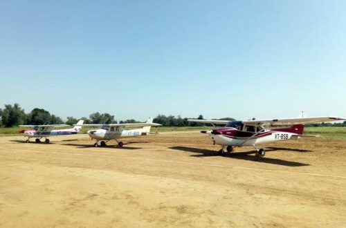
Barbil Tonto Airstrip is owned by the Government of Odisha and leased to Jindal Steel and Power Limited — a pattern identical to JSPL’s Savitri Jindal Airport at Angul, where the same company operates a state-owned airstrip for its industrial aviation needs. The 1,097-metre asphalt runway handles light executive jets, turboprops, and piston aircraft comfortably — the aircraft types that mining and steel industry executives use for regional travel between Barbil, Bhubaneswar, Raipur, Bhubaneswar, and Ranchi.
The airstrip appears in the Odisha government’s list of state-maintained airstrips under the Commerce and Transport Department and in AAI’s list of unserved airports — confirming it is on the registry of facilities eligible for UDAN scheme development if an airline expresses interest. As of mid-2026, no UDAN route had been awarded for Barbil.
The industrial case for an airstrip here is self-evident: Barbil is 310 km from Bhubaneswar by road (approximately 6 to 7 hours) and approximately 75 km from Rourkela. Senior executives of mining companies, government officials from the Mines and Steel Ministry visiting iron ore operations, and plant managers requiring rapid inter-city movement all benefit from direct aviation access. The alternative — long drives through the tribal hinterland on state highways — is time-consuming and not appropriate for frequent business travel at the executive level.
No public passenger terminal exists for commercial use. The operational infrastructure at the airstrip — a basic apron, fuel, and minimal ground handling — serves JSPL’s aviation operations.
Barbil Tonto Airstrip Connectivity: Industrial Aviation Only
By Air: No scheduled commercial passenger flights operate from Barbil Tonto Airstrip. The facility handles JSPL executive aviation and industrial corporate flights. The nearest commercial airports are Rourkela Airport (approximately 62 km north) — currently operational for government and general aviation but with limited scheduled commercial services — and Birsa Munda Airport in Ranchi (IXR, approximately 110 km north), the nearest major commercial hub.
By Road: Barbil town is well-connected within the mining belt’s road network. Rourkela is approximately 62 km north via the Barbil-Rourkela state highway (1 to 1.5 hours). Keonjhar town is approximately 65 km south. Jamshedpur (Jharkhand) is approximately 80 km north via the NH-20 corridor. Bhubaneswar is approximately 310 km south — around 6 to 7 hours on state highways.
By Rail: Barbil Railway Station is on the Kiriburu-Barbil ore-carrying railway line — primarily a freight corridor moving iron ore from mines to the national rail network. Passenger connectivity to the mainline requires transferring at Rourkela Junction (approximately 62 km north) or Cuttack for Bhubaneswar services.
Barbil Tonto Airstrip Amenities: No Public Passenger Facilities
There are no public passenger amenities at Barbil Tonto Airstrip. The leased industrial airstrip has basic operational aviation infrastructure for JSPL’s corporate use — fuel availability, a small apron, and minimal administrative support — but no passenger terminal, check-in counters, departure lounge, commercial food services, or public ground transport facilities in the airport sense.
For commercial air travel, Barbil’s mining community uses Rourkela (60 km), Ranchi’s Birsa Munda Airport (IXR, approximately 110 km), or Bhubaneswar’s Biju Patnaik International Airport (BBI, approximately 310 km) depending on their onward destination.
FAQs: Barbil Tonto Airstrip
Q1. Does Barbil Tonto Airstrip have an IATA code?
No IATA code has been assigned. The airstrip carries ICAO code VEBL per Wikipedia. The pilot navigation reference IN-0074 is used in some databases. No scheduled commercial airline booking can be made to or from Barbil.
Q2. Who owns and operates Barbil Tonto Airstrip?
The Government of Odisha owns the airstrip. It is leased to Jindal Steel and Power Limited (JSPL), which operates it for executive and corporate aviation serving the iron ore mining complex in Barbil and the surrounding Kendujhar district.
Q3. Why is Barbil Tonto Airstrip at such a high elevation?
The airstrip is at 492 metres above sea level — the natural elevation of the Bonai-Tonto plateau in northern Odisha’s iron ore belt. The Tonto hills that give the airstrip its name rise above this plateau, creating the elevated terrain characteristic of the Kendujhar district’s mining landscape.
Q4. What is the nearest commercial airport to Barbil?
Birsa Munda Airport in Ranchi (IXR, Jharkhand) at approximately 110 km is the nearest major commercial hub. Rourkela Airport in northern Odisha is approximately 62 km, though its commercial scheduled service is limited. Bhubaneswar’s Biju Patnaik Airport (BBI) is approximately 310 km south.
Q5. Could Barbil Tonto Airstrip ever host commercial flights?
Theoretically yes — it is listed in AAI’s unserved airports register and the Odisha government’s state airstrip inventory, making it eligible for UDAN scheme bidding. The 1,097-metre runway would need extension for ATR-72 class operations. As of mid-2026, no UDAN route had been awarded for Barbil.