
Jakkur is a suburb in northern Bengaluru — a zone that was agricultural land until the city’s technology-driven northward expansion absorbed it in the 2000s and 2010s. Within Jakkur sits a 214-acre aerodrome that has been part of Karnataka’s aviation landscape since 1948, carrying the ICAO code VOJV and serving as Bengaluru’s only dedicated general aviation field. The Government Flying Training School (GFTS) has operated here since 1949 or 1950 — the government’s only flying school in Karnataka, teaching commercial pilot licence candidates to fly on Cessna 152s and Cessna 172s. Jakkur Aerodrome has no IATA code, no scheduled commercial flights, a 920-metre runway too short for commercial turboprops, and a single runway oriented 08/26. What it does have is an institutional role in Karnataka’s aviation ecosystem and a physical position in one of India’s fastest-growing cities — making it simultaneously valuable, threatened by urban encroachment, and increasingly important to protect.
Quick Overview: Jakkur Aerodrome
| Detail | Information |
| Official Name | Jakkur Aerodrome |
| Location | Jakkur, North Bengaluru, Karnataka, India |
| Airport Type | Public — General Aviation / Flying Training |
| IATA Code | Not Assigned |
| ICAO Code | VOJV (also referenced as IN-0011 in some pilot databases) |
| Owner | Government of Karnataka |
| Operators | Government Flying Training School (GFTS); private aviation companies |
| Land Area | 214 acres (87 ha) |
| Established | 1948 |
| GFTS Operating Since | 1949/1950 |
| Runway Designation | 08/26 |
| Runway Length | 900–920 m × 20 m |
| Taxiway | Single taxiway on north side of runway |
| Elevation | 917 m / 3,010 ft AMSL |
| Coordinates | 13°04′37″N, 77°35′51″E |
| Nearest Weather Station | HAL Airport (~16 km south) |
| Flight Information Region | Chennai FIR |
| Scheduled Commercial Flights | None |
| Primary Use | Pilot training (CPL/PPL); microlight operations; glider training; NCC air wing; private GA companies |
Jakkur Aerodrome Location: Northern Bengaluru’s Aviation Enclave
Jakkur Aerodrome is located in Jakkur, a northern suburb of Bengaluru, approximately 16 kilometres north of HAL Airport and within the broader Yelahanka zone of north Bengaluru. The coordinates are 13°04′37″N, 77°35′51″E, at an elevation of 917 metres above mean sea level — slightly higher than HAL Airport (888 m) and very close to Kempegowda International Airport’s elevation (915 m), reflecting the consistent plateau character of the Bengaluru plateau.
Jakkur’s urban context has transformed dramatically since the aerodrome was established in 1948. What was then a relatively open agricultural suburb is now surrounded by rapidly developing residential colonies, apartments, and commercial infrastructure. The aerodrome’s 214-acre footprint sits under intense development pressure — encroachment by illegal construction, garbage dumping on the aerodrome boundary, and real estate projects testing the height restriction limits imposed around the airfield have all been documented concerns.
In October 2025, the Bruhat Bengaluru Mahanagara Palike (BBMP) mandated No Objection Certificates from aviation authorities for structures near the aerodrome — a regulatory enforcement step reflecting the ongoing conflict between urban development pressure and aviation safety requirements around the airfield’s approach and departure paths.
Nearby airfields include Yelahanka Air Force Station (adjacent zone), HAL Airport (approximately 16 km south), and Kempegowda International Airport (approximately 15 to 20 km north-northeast). The nearest METAR weather station is HAL Airport.
Jakkur Aerodrome Code: ICAO VOJV — No IATA Code
Jakkur Aerodrome carries the ICAO code VOJV. Some pilot navigation databases also list it as IN-0011 as an informal reference. No IATA code has been assigned, consistent with the absence of scheduled commercial operations. VOJV places it in the VO southern India block. The aerodrome does not publish METAR data. There is no control tower in the conventional ATC sense — air traffic control at the aerodrome is operated by the GFTS.
Jakkur Aerodrome Terminal: Karnataka’s Government Flying School and GA Hub
Jakkur Aerodrome does not have a passenger terminal for commercial use. The facility’s built infrastructure serves its general aviation and flying school mission. The Government Flying Training School (GFTS) — Karnataka’s only government-operated flying academy — has been based here since the late 1940s, although its operation has been described as “sporadic” given the funding and administrative challenges that periodically interrupt courses.
The GFTS currently operates two Cessna 152 aircraft and one Cessna 172 for training purposes. These aircraft are used for Commercial Pilot Licence and Private Pilot Licence training under DGCA-approved programmes. The school includes aircraft maintenance facilities, a hangar and storeroom, a library, and administrative infrastructure.
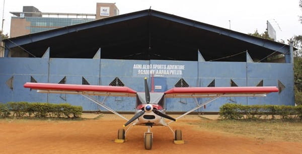
Beyond the GFTS, the aerodrome serves as a base for several private aviation companies: Deccan Charters Ltd., Jupiter Aviation, Bangalore Aerosports, and Agni Aviation have all operated from Jakkur. The aerodrome also hosts the All India Vayu Sainik Camp (AIVSC) organised by NCC Air Wing in collaboration with the Indian Air Force — a cadet aviation camp that gives NCC students their first exposure to flight in gliders and light aircraft. Microlight aviation operations and glider training are also conducted from the 920-metre runway.
The runway at 900 to 920 metres, oriented 08/26 with a parallel taxiway on the northern side, is adequate for the Cessna class and microlight aircraft that constitute the aerodrome’s regular traffic. It cannot accommodate turboprop commercial aircraft of the ATR-42 class or larger.
Jakkur Aerodrome Connectivity: Pilot Training and General Aviation Operations Only
By Air: No scheduled commercial passenger flights operate from Jakkur Aerodrome. The aerodrome handles flying school training flights (CPL/PPL on Cessna aircraft), microlight operations, glider flights, private charter, and general aviation movements for the companies based here. Public passengers cannot book commercial tickets to or from Jakkur.
By Road: Jakkur is in north Bengaluru, approximately 16 kilometres from central Bengaluru and accessible via NH-44 (Bellary Road) and local roads through Yelahanka and Hebbal. App-based cabs (Ola, Uber) serve the Jakkur area given Bengaluru’s extensive cab network. Travel time from central Bengaluru is approximately 30 to 45 minutes depending on traffic.
Nearest Commercial Airport: Kempegowda International Airport (BLR) at approximately 15 to 20 km north-northeast is the nearest commercial aviation facility — and the closest airport to Jakkur Aerodrome in operational commercial terms.
Jakkur Aerodrome Amenities: Flying School Infrastructure, No Public Passenger Facilities
The aerodrome’s amenities serve its training and general aviation community. A fuel station (AVGAS and jet-A1) is available for aircraft refuelling. Hangar facilities are leased to private operators. The GFTS has a library and maintenance workshop. Pilot training students and visiting general aviation pilots can access the airfield through its standard access framework.
There are no public passenger amenities, no check-in counters, no commercial food services, and no retail facilities. The NCC Air Wing’s AIVSC camp provides temporary cadet-oriented facilities during its periodic camps.
The aerodrome’s 214-acre footprint, in a city where land is extraordinarily valuable, is its most contested characteristic. Protecting Jakkur’s airspace and physical boundary from encroachment has been an ongoing challenge — the aerodrome is simultaneously a piece of historic aviation infrastructure and a large green space in a city that routinely struggles with development-driven loss of open land.
FAQs: Jakkur Aerodrome
Q1. Does Jakkur Aerodrome have an IATA code?
No. Jakkur Aerodrome carries the ICAO code VOJV (also referenced as IN-0011 in some pilot databases). No IATA code has been assigned as the aerodrome has no scheduled commercial passenger operations.
Q2. What is the Government Flying Training School at Jakkur?
The GFTS is Karnataka’s only government-operated flying school, based at Jakkur Aerodrome since the late 1940s. It offers Commercial Pilot Licence and Private Pilot Licence training using Cessna 152 and Cessna 172 aircraft. Operations have been intermittent given funding and administrative challenges.
Q3. Can passengers fly commercially from Jakkur Aerodrome?
No. Jakkur handles only general aviation, pilot training, microlight and glider operations, private charters, and NCC air wing camps. No commercial airline or booking service operates from here.
Q4. What is the runway length at Jakkur Aerodrome?
The single runway (designated 08/26) is approximately 900 to 920 metres long — suited to light aircraft (Cessnas, microlights) but not commercial turboprops or jets.
Q5. How is Jakkur Aerodrome threatened by urban development?
Bengaluru’s northward expansion has surrounded the 214-acre aerodrome with residential colonies and commercial development. Illegal encroachments on the aerodrome boundary, garbage dumping near the runway, illegal apartments in approach paths, and real estate projects testing height restrictions around the aerodrome are all documented issues. In October 2025, BBMP mandated aviation NOCs for construction near the aerodrome.


