
Shillong has been called the Scotland of the East since the British laid out its cantonment, planted pine forests, and built churches along its ridgelines in the 19th century. The capital of Meghalaya occupies a plateau in the Khasi Hills at 1,500 metres elevation, with a climate that keeps it cool even in summer and a landscape of waterfalls, living root bridges, and perpetual cloud cover that has made the state one of India’s most photographed tourism destinations. Shillong Airport — officially Umroi Airport, also historically called Barapani Airport — serves this remarkable state from a site 30 kilometres north of the city in the Umroi valley, carrying IATA code SHL and ICAO code VEBI. Small, unhurried, and built around a 2011 terminal, it handled 1,19,982 passengers in 2024–25, ranks far below the top 50 Indian airports by volume, and yet occupies a role of genuine strategic importance as Meghalaya’s sole commercial aviation facility — connecting the state capital to Guwahati, Kolkata, Delhi, and Imphal.
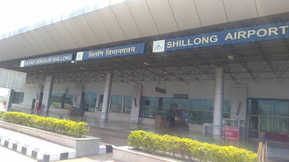
Quick Overview: Shillong Airport
| Detail | Information |
| Official Name | Shillong Airport (also: Umroi Airport; Barapani Airport) |
| Location | Umroi, Shillong, Meghalaya, India – 793103 |
| Airport Type | Public — Domestic |
| IATA Code | SHL |
| ICAO Code | VEBI |
| Operator | Airports Authority of India (AAI) |
| Hub for | IndiGo, Alliance Air |
| Developed | Mid-1960s; operational mid-1970s |
| New Terminal | Inaugurated June 2011 |
| ILS Installed | 2015 |
| Category 3C Licence | June 2019 (permits ATR-72 and Q400) |
| Single Terminal | 6 check-in counters; 100 peak-hour capacity |
| Elevation | 887 m / 2,910 ft AMSL |
| Coordinates | 25°42′13″N, 91°58′43″E |
| Distance from City Centre | ~30 km north (Police Bazar) |
| Nearest Railway Station | Guwahati (~90 km) |
| Passengers (2024–25) | 1,19,982 (+22.4% YoY) |
| Aircraft Movements (2024–25) | 2,626 (+31.6% YoY) |
| Current Airlines | IndiGo, Alliance Air |
| Active Routes | Kolkata, Guwahati, Delhi, Imphal |
Shillong Airport Location: Umroi Valley, 30 km From the Scotland of the East
Shillong Airport is located at Umroi, approximately 30 kilometres north of central Shillong (Police Bazar area) along NH-6, the Guwahati-Shillong highway. The coordinates are 25°42′13″N, 91°58′43″E, at an elevation of 887 metres above sea level — slightly higher than Imphal’s airport but far lower than Shillong city itself at approximately 1,500 metres. The airport sits in the Umroi valley, a relatively flat area carved between the Khasi Hills ridgelines, which is the primary reason it was selected over a site closer to Shillong city — the hills surrounding the city leave no space for a standard runway.
This 30-km separation is the defining inconvenience of Shillong Airport. The drive takes 60 to 90 minutes depending on traffic, road conditions on NH-6, and whether the Khasi Hills are veiled in cloud or clear. The winding hill road descends from the Shillong plateau into the Umroi valley through forests of pine and rhododendron — a scenic journey, but not a short one. Pre-booked transfers are strongly advisable as on-demand cab availability at Umroi is limited.
Meghalaya’s extraordinary natural attractions — Sohra (Cherrapunji) and Mawsynram with among the highest annual rainfalls on earth, Dawki’s crystal-clear Umngot River, the living root bridges at Nongriat, Mawlynnong (Asia’s cleanest village), and the Laitlum Canyons — are all accessed from Shillong, making the airport the air entry point for one of India’s most distinctive tourism ecosystems.
Shillong Airport Code: IATA SHL and ICAO VEBI
The IATA code is SHL and the ICAO code is VEBI. SHL is the booking identifier across IndiGo and Alliance Air platforms for Shillong. VEBI places it in the VE eastern India block. The airport received its Category 3C aerodrome licence in June 2019 — a significant upgrade that permitted the operation of larger turboprop aircraft including the ATR-72 and Bombardier Q400. An Instrument Landing System (ILS) was installed in 2015, assisting landings during Meghalaya’s frequent low-visibility conditions caused by the region’s extraordinary cloud and rainfall patterns.
Shillong Airport Terminal: A 2011 Building Built for Compact, Efficient Operations
The current terminal at Shillong Airport was inaugurated in June 2011, replacing an earlier facility that had served the airport since the mid-1970s. The terminal is a single-level structure handling both domestic arrivals and departures under one compact roof, with 6 check-in counters and a peak-hour capacity of approximately 100 incoming and 100 outgoing passengers simultaneously.
The layout is simple and deliberately compact: check-in and security immediately on entry, a departure waiting area beyond security, a gate leading directly to the aircraft on the small apron, and an arrivals area with baggage handling and exits to the taxi zone. Everything is within close walking distance — the entire passenger journey from terminal entrance to aircraft stairs takes under 20 minutes on a typical low-volume day. This is frequently cited as the airport’s practical advantage over larger, more congested regional airports.
The 22.4% passenger growth and 31.6% aircraft movement increase in 2024–25 reflect growing tourism demand for Meghalaya. Shillong’s emergence as a significant domestic tourism destination — driven by social media attention to Meghalaya’s waterfalls and living root bridges, the growth of eco-tourism, and state government tourism promotion — has translated into consistent growth at SHL. Development plans and expansion discussions have been raised but no confirmed new terminal project had been announced as of mid-2026.
Shillong Airport Connectivity: IndiGo and Alliance Air to Four Destinations
By Air: IndiGo and Alliance Air are the two scheduled commercial carriers at Shillong. IndiGo connects Shillong to Kolkata and Guwahati with daily ATR flights, along with Delhi and Imphal services. Alliance Air also serves the Guwahati route. As with all small Northeast regional airports, route availability and frequencies fluctuate seasonally — always confirm current schedules directly with the airline before booking and before arranging accommodation dates in Meghalaya.
Weather Advisory: Shillong Airport is in one of the world’s highest-rainfall zones. Meghalaya’s monsoon (June-September) and associated low cloud, fog, and reduced visibility can delay or divert flights with some regularity. The ILS system helps, but the airport is not equipped with the precision approach aids of larger airports. Build buffer time into onward travel plans during monsoon season.
By Road: Pre-paid taxis from the airport to Police Bazar (central Shillong) are the most reliable option, with fares posted at the airport counter. Travel time is 60 to 90 minutes depending on traffic. Shared sumos (jeeps) are a cheaper, slower traditional Northeast transport option. State transport buses synchronise with flight timings. From Shillong, shared taxis connect to Sohra (Cherrapunji, ~50 km), Dawki (~80 km), and other Meghalaya destinations.
By Rail: There is no railway station in Shillong or Meghalaya. Guwahati Railway Station — one of Northeast India’s major junctions, approximately 90 km from the airport — is the nearest broad-gauge rail connection to the rest of India.
Shillong Airport Amenities: Compact and Efficient for Hill Station Travel
Shillong Airport’s amenities match its scale well. Free trolleys are positioned at the terminal entrance. Wheelchair assistance and elderly passenger support are available. A child care room is accessible. Lost and found baggage services operate. Security screening is straightforward at this volume. A cafeteria and snack kiosks serve light meals, tea, and regional refreshments — Meghalaya’s Jadoh (rice and pork), Tungrymbai, and local seasonal produce appear in food options near the terminal zone.
Eateries and taxi services are available outside the terminal. A duty-free shop is listed in IndiGo’s directory, though the scope is limited relative to major airports. Tourist information is available to arriving visitors exploring Meghalaya for the first time.
FAQs: Shillong Airport
Q1. What is the IATA code for Shillong Airport?
The IATA code is SHL and the ICAO code is VEBI. The airport is officially Umroi Airport (also Barapani Airport), located at Umroi, approximately 30 km north of Shillong city. Address: Umroi, Meghalaya 793103.
Q2. How far is Shillong Airport from the city and how long does the drive take?
Approximately 30 km from Police Bazar (city centre), taking 60 to 90 minutes by road via NH-6 depending on traffic and hill road conditions. Pre-booked taxis are strongly recommended as on-demand cab availability at Umroi is limited.
Q3. Why is Shillong Airport not in Shillong city itself?
The Khasi Hills surrounding Shillong city at approximately 1,500 metres elevation leave no flat ground for a standard runway. The Umroi valley 30 km north provides the relatively flat terrain needed for safe takeoff and landing operations.
Q4. Is Shillong Airport reliable during the monsoon? Meghalaya is among the world’s highest-rainfall zones and the monsoon (June-September) causes frequent low-cloud and visibility-reduction events at Umroi. An ILS system (installed 2015) helps, but delays and diversions are more common here than at drier-climate airports. Always plan buffer time during monsoon travel.
Q5. What is the nearest railway station to Shillong Airport?
Guwahati Railway Station is approximately 90 km from the airport — the nearest broad-gauge railway junction. There is no railway connectivity within Meghalaya. Most travellers combine a flight into SHL with road transport onward, or fly into Guwahati (GAU) and drive approximately 3 hours to Shillong by road.


