
Akola is a city in the Vidarbha region of Maharashtra — the eastern cotton belt that runs from Nagpur to the Maharashtra-Madhya Pradesh border, a zone of agricultural commodity trade, textile ginning, and significant social tension around farmer distress. Akola district has been among the most severely affected by the agrarian crisis in Maharashtra, but it is also a commercial hub for Vidarbha’s cotton and soybean economy. Akola Airport — officially named Dr. Panjabrao Deshmukh Domestic Airport after the first State Agriculture Minister of India — carries IATA code AKD and ICAO code VAAK, was built in 1943, and is currently non-functional for public use. No commercial airline operates from Akola. The airport sits on 196 acres with a 1,400-metre part-concrete, part-asphalt runway, a small terminal capable of 20 passengers, and an apron for two Fokker F-27 class aircraft. AAI has requested state government land for runway extension to 1,800 metres. The airport’s history includes Vayudoot and Span Aviation operations in earlier eras, neither of which continued into the commercial aviation period that followed liberalisation.
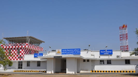
Quick Overview: Akola Airport
| Detail | Information |
| Official Name | Dr. Panjabrao Deshmukh Domestic Airport (also: Akola Airport; Shiwani Airport) |
| Location | Akola, Maharashtra, India (~7 km from city on NH-6) |
| Airport Type | Public — Non-operational for commercial flights |
| IATA Code | AKD |
| ICAO Code | VAAK |
| Owner | Government of Maharashtra |
| Operator | Airports Authority of India (AAI) |
| Named After | Dr. Panjabrao Deshmukh (first State Agriculture Minister of India) |
| Built | 1943 (Public Works Department) |
| Developed | 2008 (₹25 crore investment) |
| Land Area | 196 acres |
| Runway Designation | 10/28 |
| Runway Length | 4,600 ft / ~1,400 m (extended from 4,000 ft in 2008 development) |
| Apron | 90 m × 100 m; 2 Fokker F27-class aircraft |
| Terminal Capacity | ~20 passengers |
| Elevation | 304 m / 999 ft AMSL |
| Coordinates | 20°41′56″N, 77°03′31″E |
| Nearest Weather Station | Jalgaon Airport (~151 km) |
| Flight Information Region | Mumbai FIR |
| Scheduled Commercial Flights | None (non-functional for public use) |
| Runway Extension Request | AAI requested state government land for extension to 1,800 m |
Akola Airport Location: Vidarbha’s Cotton Belt Gateway
Akola Airport is located approximately 7 kilometres from Akola city centre on National Highway 6 (the Mumbai–Kolkata highway). Coordinates are 20°41′56″N, 77°03′31″E, at an elevation of 304 metres above mean sea level. The 196-acre site is in the flat agricultural terrain of Vidarbha’s cotton belt.
Akola’s position in central Vidarbha gives the airport a potential catchment covering Akola district, adjacent Washim district, and portions of Buldhana to the west. The city is a major agri-commodity trading hub — cotton, soybean, and tur dal are traded at Akola’s Agricultural Produce Market Committee, which is among Maharashtra’s most active. The industrial profile includes cotton ginning and pressing, edible oil processing, and textile manufacturing.
Named after Dr. Panjabrao Deshmukh — the Vidarbha-born agrarian reformer who served as India’s first Agriculture Minister and founded Shri Shivaji Education Society, which built educational infrastructure across Maharashtra — the airport’s name honours one of Vidarbha’s most consequential political figures. The name also reflects Akola’s deep connection to agricultural identity.
Nearby airfields include Amravati Airport (AVR, approximately 38 nautical miles southeast — the nearest airport), and Nagpur Airport (NAG, Dr. Babasaheb Ambedkar International Airport, approximately 200 km east), which is the nearest major commercial airport for Akola residents.
Akola Airport Code: IATA AKD and ICAO VAAK
The airport’s IATA code is AKD and its ICAO code is VAAK. AKD is formally assigned but does not appear in active airline booking systems as no commercial flights operate. VAAK places it in the VA western India block. The airport does not publish METAR weather data — the nearest weather station is Jalgaon Airport, approximately 151 km west. The Flight Information Region is Mumbai FIR.
Akola Airport Terminal: Developed in 2008, Unused Since
Akola Airport’s history runs through several distinct phases. The original airfield was built in 1943 by the PWD during World War II. Vayudoot operated flights from Akola in the post-independence scheduled aviation era. Span Aviation also operated at some point. Neither commercial era was sustained.
In 2008, the Maharashtra state government invested approximately ₹25 crore in airport development. The runway was extended from 4,000 feet to 4,600 feet (approximately 1,219 to 1,400 metres). A new terminal building was constructed. A new fire station and air traffic control block were installed. A Precision Approach Path Indicator (PAPI) and Non-Directional Beacon (NDB) navigation system were added. These upgrades materially improved the airfield from its 1943-vintage state.
The terminal building is small — capable of handling approximately 20 passengers at a time. The apron covering 90 × 100 metres accommodates two Fokker F-27 class aircraft simultaneously. The part-concrete, part-asphalt, part-bitumen-bound macadam runway is oriented 10/28 and now 1,400 metres long.
Despite the 2008 investment, no airline commenced commercial operations at Akola. The runway at 1,400 metres remains below the 1,500 to 1,800 metres that would enable ATR-72 class turboprop commercial operations at full load. AAI has formally requested the Maharashtra state government to provide additional land to extend the runway to 1,800 metres (5,900 feet) — the threshold that would enable modern turboprop commercial services. As of mid-2026, this land has not been provided and the runway extension has not been executed.
The airport is currently described as non-functional for public use, with no airlines operating and the terminal effectively dormant for commercial passenger activity.
Akola Airport Connectivity: No Commercial Flights; Road to Nagpur or Amravati
By Air: No scheduled commercial passenger flights operate from Akola Airport as of mid-2026. The airport is non-functional for public use.
By Road: Akola city is on NH-6 (Mumbai–Kolkata highway), with direct road connectivity to Nagpur (approximately 200 km east, 3 to 3.5 hours), Amravati (approximately 65 km east, 1 hour), Aurangabad (approximately 290 km west, 4.5 hours), and Pune (approximately 470 km south, 7 to 8 hours). Taxis, auto-rickshaws, and MSRTC state buses serve routes within Vidarbha.
By Rail: Akola Railway Junction is a significant station on the Bhusaval-Nagpur section of the Central Railway, with direct trains to Mumbai, Nagpur, Hyderabad, and other cities. The Vidarbha Express and multiple Mail and Express trains serve the Akola-Nagpur and Akola-Mumbai corridors.
Nearest Commercial Airport: Amravati Airport (AVR) at approximately 65 km is the nearest currently operational commercial airport (opened April 2025), with Alliance Air service to Mumbai. Nagpur Airport (NAG, Dr. Babasaheb Ambedkar International Airport) at approximately 200 km is the nearest major aviation hub with comprehensive domestic and international connectivity.
Akola Airport Amenities: 2008 Terminal, Not in Public Use
The terminal building constructed in the 2008 development exists but is not actively serving passengers. The fire station, ATC block, PAPI, and NDB installed in 2008 represent functional aviation safety infrastructure maintained on the airfield. The small terminal with its 20-passenger capacity is not providing commercial passenger services.
There are no active commercial amenities — no check-in counters in public use, no departure lounge services, no food outlets operating, and no commercial ground transport dedicated to airline passengers.
For travellers in Akola seeking air connectivity, the practical options are road travel to Amravati (65 km) for Alliance Air Mumbai flights, or road-rail to Nagpur for comprehensive aviation access.
FAQs: Akola Airport
Q1. What is the IATA code for Akola Airport?
The IATA code is AKD and the ICAO code is VAAK. The airport’s official name is Dr. Panjabrao Deshmukh Domestic Airport, located approximately 7 km from Akola city on NH-6.
Q2. Why is Akola Airport non-operational?
The 1,400-metre runway is below the standard required for commercial ATR-72 turboprop operations at full load. AAI has requested the state government to provide additional land for runway extension to 1,800 metres, but this land has not been transferred and no airline has commenced services.
Q3. Who was Dr. Panjabrao Deshmukh?
Dr. Panjabrao Deshmukh was a Vidarbha-born agrarian reformer, social activist, and the first State Agriculture Minister of independent India. He founded the Shri Shivaji Education Society, which built educational institutions across Maharashtra, and is particularly revered in the Vidarbha region.
Q4. Has any airline ever operated from Akola Airport?
Yes. Vayudoot and Span Aviation operated flights from Akola in earlier eras. Neither sustained commercial operations. The 2008 airport redevelopment did not attract any airline, and the airport has been non-functional for commercial use since then.
Q5. What is the nearest operational commercial airport to Akola?
Amravati Airport (AVR, approximately 65 km east) with Alliance Air Mumbai service (from April 2025) is the nearest operational commercial airport. Nagpur Airport (NAG) at approximately 200 km east is the nearest major hub.


